Water
Ski Resorts Are Turning Wastewater into Snow
This story was originally published by Montana Free Press at montanafreepress.org.
The Yellowstone Club, the elite resort near Big Sky that in the past has counted Bill Gates, Justin Timberlake and Jessica Biel as members, has become the first ski area in Montana to turn wastewater into snow. And while skiing on what was once sewage might seem odd at first blush, resort officials and local conservation groups said it’s both safe and beneficial to the environment, especially during dry winters like this one, which has left some ski areas in the state shuttered.
In fact, Richard Chandler, vice president of environmental operations for the Yellowstone Club, said recently that the new program to turn wastewater into snow is helping the resort open more runs than it otherwise might be able to this winter.
“Without [snowmaking], we’d be skiing on a lot less terrain,” Chandler said.
The new effort to use recycled water to increase the base layer of snow on Eglise Mountain follows a decade of collaboration between the resort and local environmental groups, plus a multi-year review by state regulators. It isn’t the first time the Yellowstone Club has found a new use for wastewater: For several years, it has been using recycled water to irrigate its golf course.
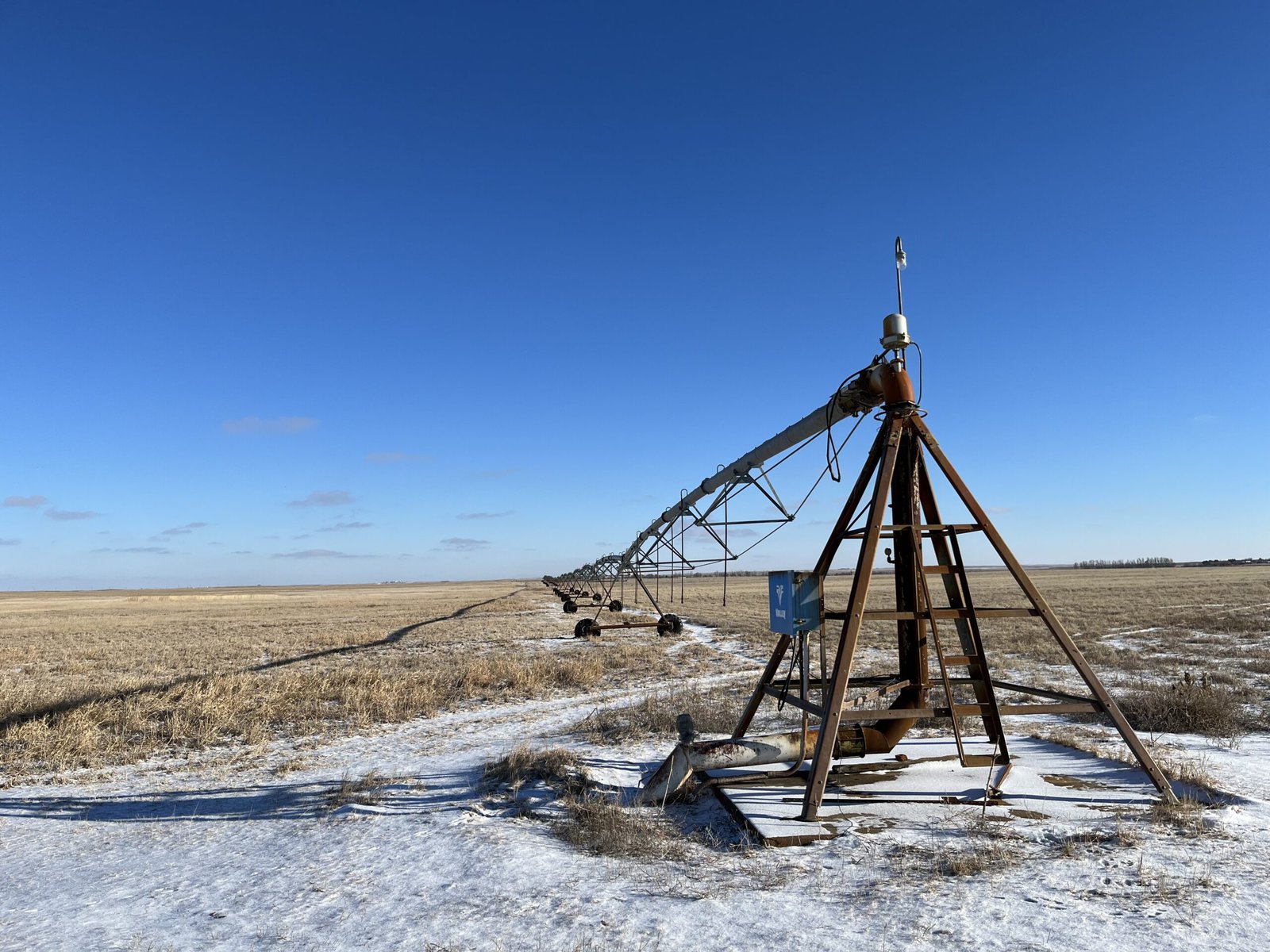
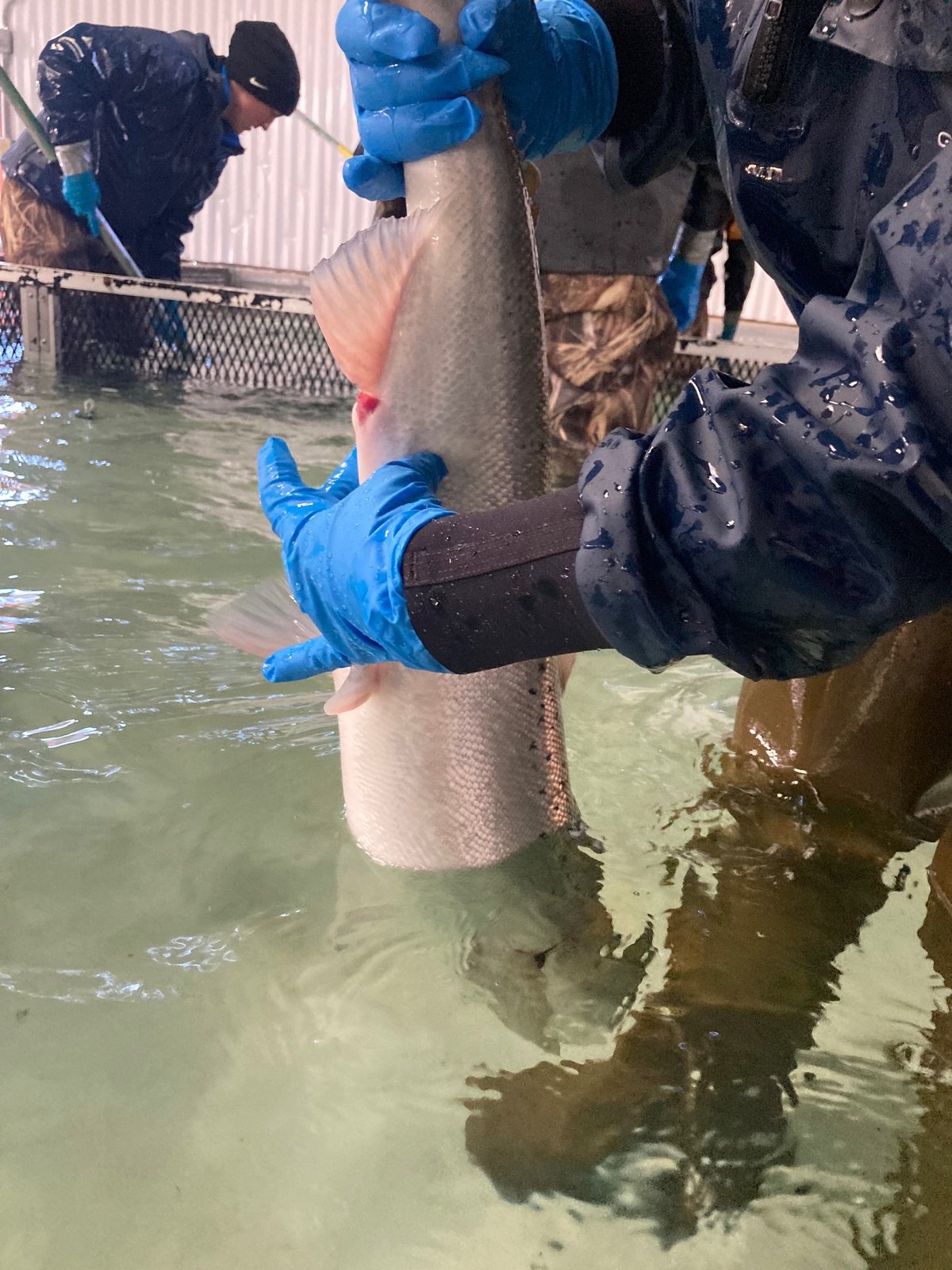
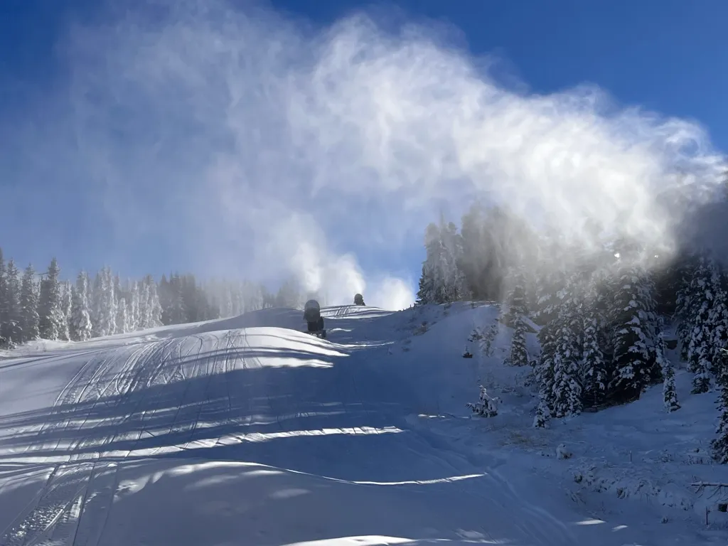 Officials at the Yellowstone Club say that using wastewater to make snow has allowed the resort to open more terrain to skiers this winter. Courtesy of the Yellowstone Club
In 2011, the Gallatin River Task Force, Yellowstone Club and DEQ studied whether wastewater could be used to make artificial snow to ski on. The idea was that as climate change made the region’s snowpack more unpredictable, they could serve skiers and the watershed by making snow from treated water that is traditionally just put into rivers and other bodies of water. That winter they successfully turned a half-million gallons of wastewater into two acres of snow about 18 inches deep.
According to the Yellowstone Club, 12 ski areas in eight states, plus some in Canada, Switzerland and Australia, have used wastewater to make snow in the past. However, the practice hasn’t been without controversy. About a decade ago, a ski area near Flagstaff, Arizona, was sued by a local tribe over environmental concerns about turning wastewater into snow. The Hopi Tribe also alleged that the practice would desecrate a mountain it considered sacred. The tribe eventually lost in court, but during the dispute some environmental groups, including the Center for Biological Diversity, raised concerns about the impact the recycled snow might have on aquatic life in the area.
But Chandler said that using recycled water to make snow treats the wastewater even more than it normally would be before being released into a river. By shooting it through the snowmaking equipment (it’s essentially misted onto the slopes as snow) the wastewater is treated again. Then, as it melts in the spring and enters the ground, it’s filtered a third time. Chandler also said that the compacted snow on the slopes will last longer into spring and summer, adding water to the aquifer at a critical time and helping streamflows later in the season. Because of that, groups like the Gallatin River Task Force, Trout Unlimited, American Rivers, Great Yellowstone Coalition and the Association of Gallatin Agricultural Irrigators all came out in favor of the project. Chandler estimates that the man-made snow will increase summer runoff in area creeks by about 19 days.
Crushed by negative news?
Sign up for the Reasons to be Cheerful newsletter.
[contact-form-7]
“The benefits of this project are actually an enhancement to the watershed function,” said Pat Byorth, Montana water director for Trout Unlimited, in a press release. “It’s an enhancement to water supply, to water quality in the basin. So everybody from skiers to anglers will benefit from this, and downstream agriculture benefits at a time where water supply is uncertain.”
In 2020, the Yellowstone Club applied for a permit from DEQ to expand that 2011 pilot program into a permanent snowmaking operation on Eglise Mountain. The following year, the state issued a permit allowing the Yellowstone Club to turn 25 million gallons of wastewater into snow annually. Two years and $12 million later, the new system began making snow last November. Under the current plan, 80 percent of the recycled water is coming from the community of Big Sky and 20 percent is coming from the Yellowstone Club. As part of its permit, the Yellowstone Club is required to erect signage warning visitors not to consume the snow.
As winters get drier in the American West, Chandler said that turning wastewater into snow could be the key for ski areas across the region in the future. He said he hopes the club can set an example.
“We hope that we can show other ski areas in the state what is possible,” he said. “We might be the first, but I hope we aren’t the last.”
The post Ski Resorts Are Turning Wastewater into Snow appeared first on Reasons to be Cheerful.
An Ancestral River Runs Through It
Jeff Wivholm isn’t partial to mountains. He likes to be able to see the weather rolling in, something remarkably possible in the northeastern corner of Montana.
On a cold January morning, Wivholm drives the dirt roads between farms in Sheridan County, where he’s lived for all his 63 years, with practiced ease, pointing out different plots of land by who owns them. And if he doesn’t know the family name, Amy Yoder with the Sheridan County Conservation District or Brooke Johns with the Medicine Lake National Wildlife Refuge — both sitting in the backseat of his truck — can supply it.
If you look to the right there, Wivholm says, you can see the valley created by the aquifer. Maybe he can, his eyes accustomed to seeing dips and crevasses in, to an unfamiliar eye, a starkly flat landscape. He laughs and says it takes some getting used to.
That aquifer isn’t unique in Montana. There are 12 principal aquifers running like underground rivers throughout the state. But the way Sheridan County uses the water is.
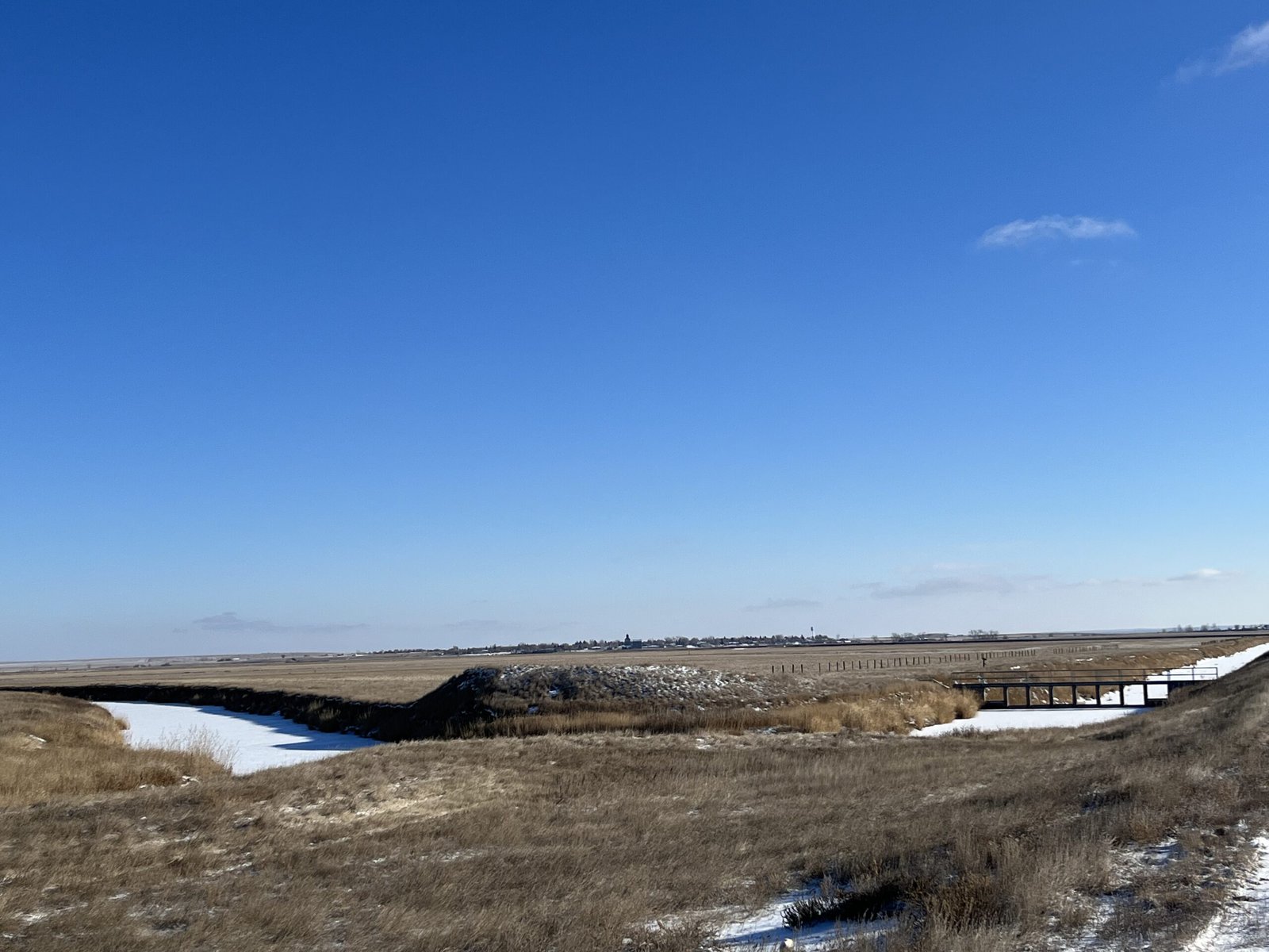 The Big Muddy Creek flows through dams and diversions, pictured on the right, that are managed by the Medicine Lake National Wildlife Refuge to fill the lake as needed. Credit: Keely Larson
Montana is in relatively good shape as far as its groundwater supply goes, something uncommon across much of the country, geologist John LaFave with the Montana Bureau of Mines and Geology says. State politicians initiated a groundwater study over 30 years ago after years of intense drought and fires and a lack of data.
But Sheridan County was ahead of the game: The county’s conservation district started studying its groundwater in 1978, before state monitoring began.
In 1996, the district was granted a water reservation, or water allocated for future uses, from the state, which meant it could take a certain share of water from the Clear Lake Aquifer. Because of all the data it gathered through studying its groundwater, the district developed a unique way of using and distributing that water.
What’s unusual is how intentional the collaboration was and how extensive the groundwater monitoring was and continues to be. The district does this by working with farmers, tribes and the US Fish & Wildlife Service (USFWS) to ensure water can be used by those who need it — those who would be most affected by any degradation to the water — without negatively impacting the environment.
And it’s worked. The conservation district has been using its geologically special aquifer — a gift granted to this area by the last Ice Age — to irrigate crops, provide jobs for the region and keep agriculture dollars within the community for almost 30 years while fielding few complaints.
“To me, this represents the way groundwater development should occur,” LaFave says.
Sheridan County is extremely rural, home to about 3,500 people across its 1,706 square miles. Agriculture is a big economic driver. Bird hunting is an attraction for locals and visitors. The Medicine Lake National Wildlife Refuge, located in both Sheridan and Roosevelt Counties and managed by the USFWS, is home to many migratory bird species. It’s the largest pelican breeding ground in Montana and the third-largest in the country.
This early January morning, it’s about five degrees, but there isn’t a lot of snow on the ground. Over coffee and breakfast in Plentywood — the county seat — Yoder and Wivholm say this winter has been warmer and drier than usual.
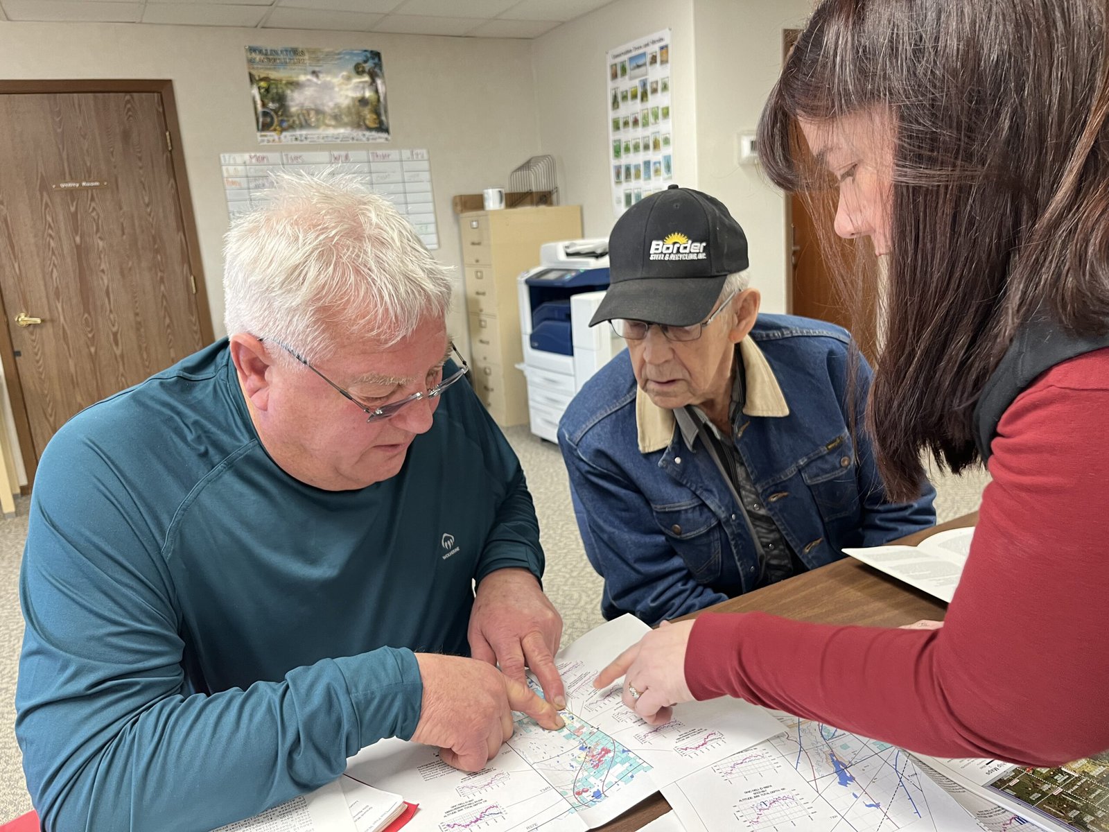 From left to right, Jeff Wivholm, Marlowe Onstead and Amy Yoder look through maps of irrigation pivots and aquifer allocations inside the Sheridan County Conservation District office in Plentywood. Credit: Keely Larson
Dry weather is not uncommon here. Droughts in the 1930s and ’80s were particularly rough. Also in the ’80s, irrigation technology was becoming more common and efficient, Wivholm says, and people began to pay more attention to the possibility of an aquifer as a way to ensure water would be available for irrigation.
“There are several nicknames for much of this property, but it was basically ‘poverty flats,’” Jon Reiten, hydrogeologist with the Montana Bureau of Mines and Geology, says. The soil is sandy, gravelly and drought-prone. Not great for dry-land farming.
Marlowe Onstead was the first farmer in Sheridan County to use the aquifer for his pivot irrigation in 1976.
“Couldn’t raise the crop on it before,” Onstead says. After irrigation, he was able to grow alfalfa.
According to Reiten, the aquifer ranges from a mile to six miles wide and two to three hundred feet deep. The ancestral Missouri River channel, discovered in Sheridan County in 1983 as monitoring began, flowed north into Canada and east into Hudson Bay. That channel was dammed by glaciers in the last Ice Age and left behind a reservoir that was buried as glaciers melted, creating the Clear Lake Aquifer. Since the materials left behind were coarse and varied, water could move easily and be stored in great depths. A downside is that these glacial aquifers can take a long time to refill.
 The vertical white cylinder is one of many that Amy Yoder with the Sheridan County Conservation District checks throughout the growing season. She opens up the top, connects the data logger inside to a laptop and collects information on the aquifer water level and how much water has been used for irrigation. Credit: Keely Larson
As drought dragged on in the ’80s, locals and county and state authorities set about figuring out the best way to distribute the aquifer’s water. Medicine Lake lies on top of some of the aquifer, and the Big Muddy Creek — where the Fort Peck Tribes require a minimum in-stream flow to promote ecosystem health — is at its southwestern border.
The Fort Peck Tribes and the USFWS were concerned about their respective water levels and how they’d be impacted by irrigation. Reiten says the USFWS was objecting to just about every water rights case that went to the state at the time, and all that litigation ended up in water court.
“That’s a lot to put on a producer, to have to go up against the federal government,” Reiten says.
Negotiations with the USFWS and the Fort Peck Tribes led to the formation of an advisory committee and the transfer of the water reservation on the aquifer from the state to the conservation district. (Per Montana water law, all water belongs to the state and individuals are required to get a water right to use it in a particular way — in this case, for irrigation.) Since then, Sheridan County Conservation District has had the authority to give water allocations from the Clear Lake Aquifer to producers without the producers having to appeal to the state.
The maximum amount of water that can be pulled from the aquifer is just over 15,000 acre feet total, a number set by the state’s Department of Natural Resources and Conservation. Currently, the district is using about 10,000 acre feet. Increases are allowed as long as monitoring shows the aquifer isn’t being overly impacted by irrigation.
Credit: Keely Larson
The Medicine Lake National Wildlife Refuge is home to the third largest pelican breeding ground in the country and the largest in Montana. Negotiations with the US Fish & Wildlife Service, which manages the refuge, helped Sheridan County Conservation District obtain the water reservation for the Clear Lake Aquifer.
“We were basically forced to monitor it, but it only makes good sense,” Wivholm, who has been on the conservation district board since 1994, explains. The district wouldn’t want to grant someone a right only to find out in five years that there’s not enough water.
Once a year, the committee meets to assess new water rights. The committee includes the Montana Bureau of Mines and Geology, the state Department of Natural Resources and Conservation, representatives from the Medicine Lake National Wildlife Refuge, county commissioners, a county planner, the Fort Peck Tribes and a representative with the United States Geological Survey.
If a farmer wants an irrigation pivot, they have to “pump it hard for 72 hours,” Wivholm says, to make sure there is enough water for their request, and understand how that pumping affects other wells nearby.
Data comes from Yoder’s efforts. She collects readings from data loggers placed in the ground throughout the county from April through October. For the first and last collections, she visits 201 wells and it takes her three 12-hour days to get to them all. Driving around in Wivholm’s truck, she points out some of her data loggers sticking up from the ground every few minutes.
Through monitoring, Sheridan County Conservation District and the Montana Bureau of Mines and Geology have been able to map the entire aquifer. They take note of the water levels, monitor each irrigation pivot and can see seasonal fluctuations.
 Rodney Smith’s pivot is the largest connected to the aquifer. The structure in the foreground remains stationary, while the rest on wheels moves around — pivots around — the fixed structure. Credit: Keely Larson
“It’s kind of a hidden resource, but the amount of crops that we can get off of the poor ground that is above the aquifer is amazing,” Yoder says. She lists corn, wheat, chickpeas, lentils, canola, mustard and alfalfa.
Another farmer in the area, Rodney Smith, has been irrigating from the Clear Lake Aquifer for over 35 years and has the biggest pivot connected to the aquifer.
Smith says irrigating has been economically beneficial: His farm isn’t as dependent on the weather, and it’s taken the risk out of production. Smith Farms Incorporated produces hay for livestock and sells it to other ranchers in the area. Smith also leases land out to other farmers who grow potatoes and sugar beets.
From an aerial view, his circular pivot plots show different colors of green and brown, indicating a variety of crops grown.
Smith had an early contested pivot case with the state of Montana, before the water reservation was transferred to the conservation district, which went to the state water court.
The gist of the case was that Smith Farms wanted to change their method of irrigation and the USFWS was concerned it might impact the Medicine Lake National Wildlife Refuge. Data and monitoring done by the conservation district backed up Smith’s case.
“When you start irrigating, you wonder what is the capacity, or how much can you irrigate,” Smith says. “It’s always interesting to know what it’s doing.”
Credit: Google Earth
Land that is irrigated with pivot irrigation shows up in circular plots from above due to the way the structure pivots around a fixed point. Here, the circular pivot plot is sliced into different colors where different crops or phases of harvest have occurred.
Johns, with the wildlife refuge, says the refuge has a water reservation on Medicine Lake and is allowed to keep the lake filled for the protection of migratory birds. The refuge operates dams and diversions to maintain this need. Making sure any irrigation wouldn’t draw down the level of the lake has been a goal from the beginning, Johns says, and so far, that hasn’t been an issue.
There haven’t been any other contested cases on aquifer irrigation, and many, including Smith, see this as a success in having local control over a local resource.
“Water rights are such a contentious thing,” Johns notes. “And without the data, had they not started this years ago, it would be hard to start it today and get the same momentum they did.”


Become a sustaining member today!
Join the Reasons to be Cheerful community by supporting our nonprofit publication and giving what you can.
Arnold Bighorn, water rights administrator for the Fort Peck Tribes, says the collaboration between all those affected by the aquifer — counties, tribes and the wildlife refuge — has worked well.
“Everybody’s on the same page, which is good,” Bighorn says.
Monitoring groundwater like this is unique in Montana, according to Reiten, particularly for irrigation development. But there are successful examples in other states.
Before he came to Montana, Reiten worked for the North Dakota State Water Commission, where the same type of monitoring was going on that he helped start in Plentywood. He is working on another aquifer in Sidney, Montana, about 85 miles south of Plentywood, to develop a similar system.
“We’re applying the same methods there to try to develop that aquifer without affecting anything else,” Reiten says.
 Wivholm, who has lived in Medicine Lake, Montana for all his 63 years of life, drove along dirt roads earlier in the day with ease, knowing the pheasants and grouse would flap out of the way as his truck sped along. Credit: Keely Larson
Many conservation districts across Montana have water reservations on surface water, Yoder says, but Sheridan County Conservation District is one of only two districts that manages a groundwater reservation.
“I haven’t heard of any other places that have quite the extensive monitoring that we have and the time range that we have,” Yoder says.
There continues to be room for more water and improvement in how it’s used.
Wilvhom would like to see soil monitoring, so producers can know when to water and when they’re using too much. Devices are available that farmers could bury in the ground to monitor soil moisture and temperature.
Managing the aquifer has been “a collaboration to help the whole community do good,” Wivholm reflects later in the week, when Plentywood has reached -58 degrees with a windchill. “It helps the whole health of the whole ecosystem.”
The post An Ancestral River Runs Through It appeared first on Reasons to be Cheerful.
A Ranch, Rewilded: The Transformation of California’s Next State Park
On a bright morning in early January near the confluence of the San Joaquin and Tuolumne rivers in Central California, John Cain looks out over a small, curved lake. The trees are mostly bare for winter, but Cain, senior director of conservation of the nonprofit organization River Partners, points out that the wild landscape in front of him is buzzing. Bright white egrets swoop lazily down into the water while terns whiz by in the air. A California rose bush clings onto bright red rose hips. The low-lying plain across the water is dense with gray branches of adolescent trees.
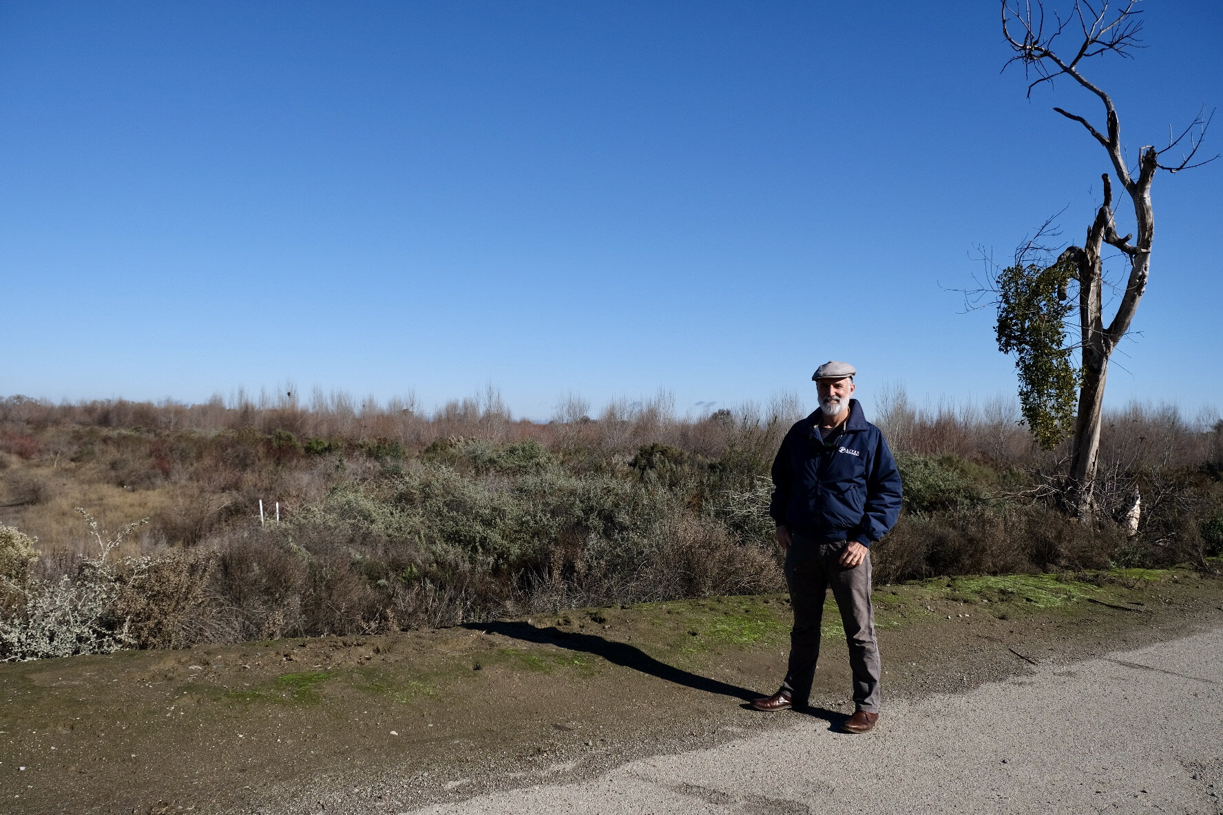 John Cain of River Partners. Credit: Elizabeth Hewitt
For more than four months last year, as California was inundated with a series of major storms, this part of Dos Rios Ranch Preserve, about 20 miles west of Modesto, was submerged under water. That’s exactly what it was designed for. And when the floodwaters recede, Cain says, “It’s just an explosion of life out here.”
Until a little more than a decade ago, this area was productive farmland, used for growing crops like tomatoes, alfalfa, melons and almonds. Now it’s set to be California’s next state park after a restoration project spearheaded by River Partners converted the ranch into rewilded riverside habitat. As climate change has doubled the likelihood of flooding in California, and is projected to increase runoff from storms by as much as 200 to 400 percent, this restored floodplain is proving to be a promising approach.
The post A Ranch, Rewilded: The Transformation of California’s Next State Park appeared first on Reasons to be Cheerful.
The Cheap, Clever Promise of ‘Water ATMs’
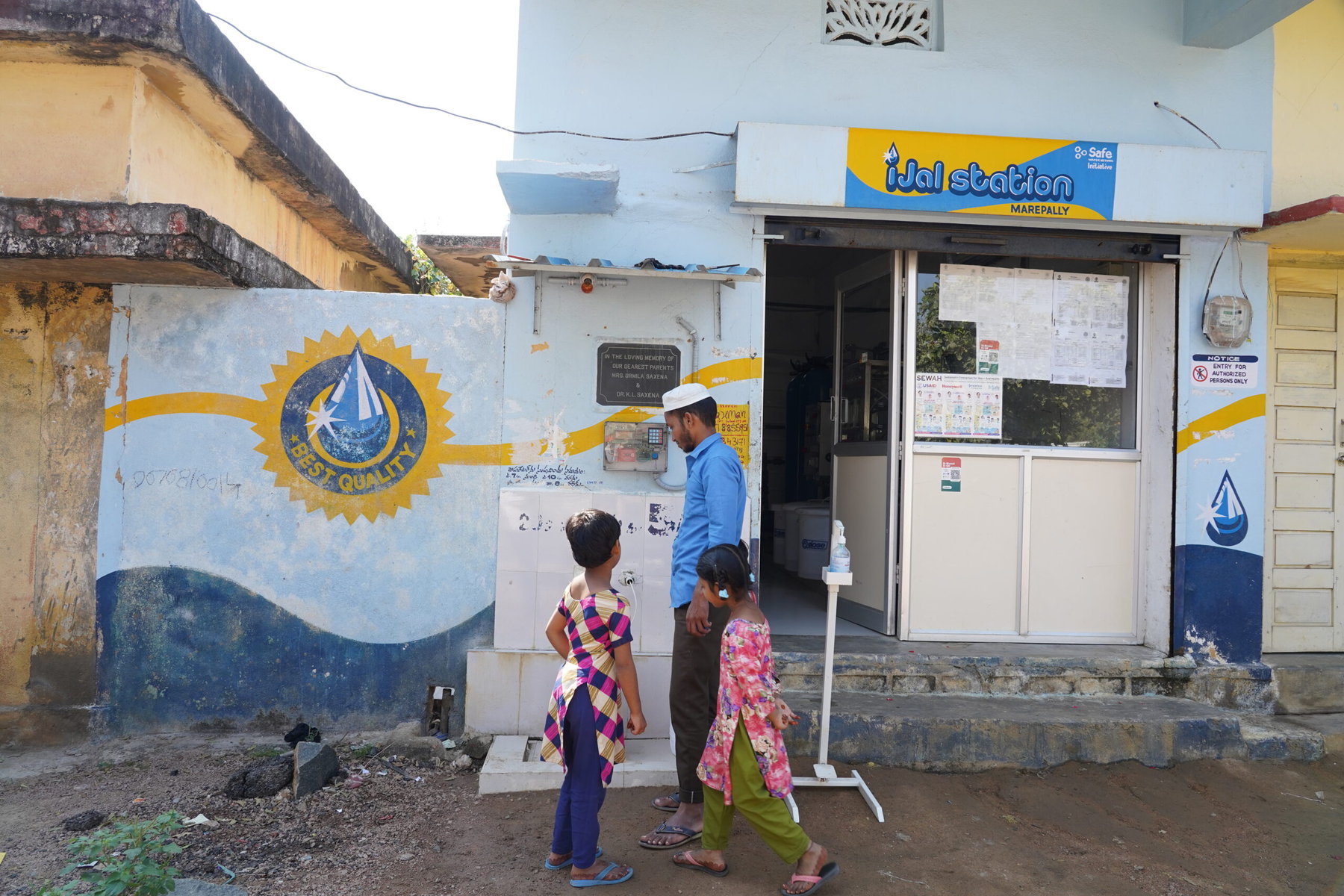
In Telangana, an arid south Indian state notorious for drought, a man swipes a card at an ATM. Instead of cash, the machine doles out 20 liters of clean drinking water. The ATM is housed in an iJal (My Water) station, run by 31-year-old Somarathi Sindhuja, a petite mother of two. When she set it up seven years ago, she had not imagined that her seed money of Rs 2,00000 (just under $2400 US) would help her create what she today calls her “public service business,” which supplies clean drinking water within a two-mile radius of her home in Warangal, Telangana’s second largest city.
Sindhuja is one of the 350 rural water entrepreneurs trained and supported since 2017 by Safe Water Network (SWN), an American nonprofit founded in 2006 by the late actor and philanthropist Paul Newman and other civic leaders. The entrepreneurs buy or provide the space for the water filtration equipment and ATM, as well as the raw water. SWN provides them with the necessary training, technical support and water treatment expertise. Using all this, they are able to filter water to international safe drinking water standards and sell it for the nominal sum of Rs 5 ($0.07 US) for 20 liters.
That’s an extremely good deal for the community: Typically the price for a similar quantity of water, from a competing supplier like commercial tanker owners, is at least double this amount; bottled water can go for as much as 10 times more. It’s a good deal for the entrepreneur, too. “I earn about Rs 15,000 to 20,000 (roughly $180 to $240 US) per month from this, which is amazing as there are hardly any jobs available to women like me here,” Sindhuja says. “And I’m also improving the lives of people in my neighborhood.”
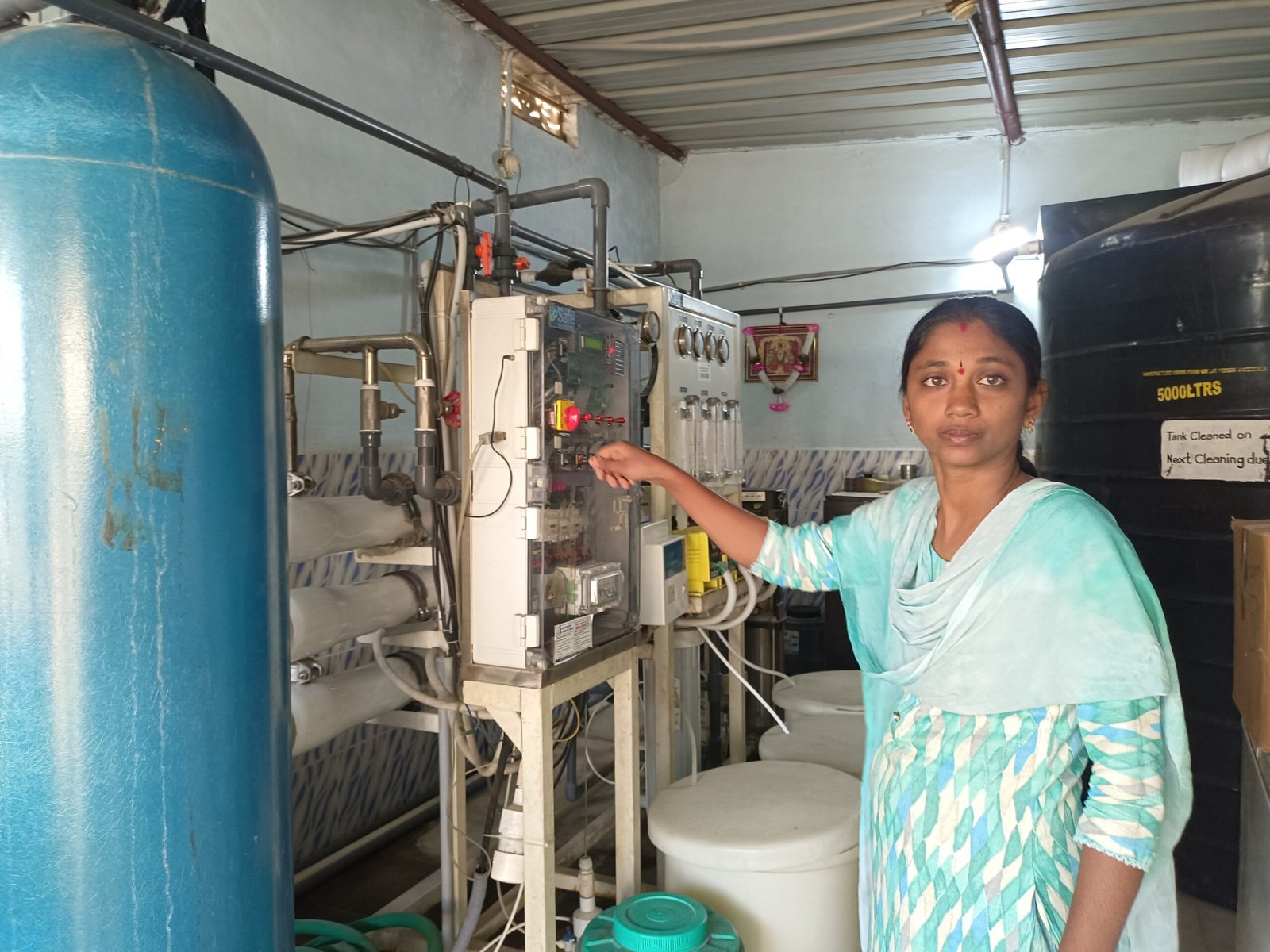 Sindhuja says her iJal station gets about 200 customers per day. Credit: Raj Kumar / Safe Water Network
Warangal is undeniably parched, and the water that most residents there can easily access is not safe to drink. And it’s not alone in these challenges: Due to depleting groundwater reserves, erratic rainfall and poor civic infrastructure, an estimated 2.2 billion people across the globe were unable to get safe drinking water in 2022. In India, thanks to the government’s ambitious piped water scheme Har Ghar Nal ka Jal (Water on Tap in Every Home), things are looking up — but a lot more needs to be done.
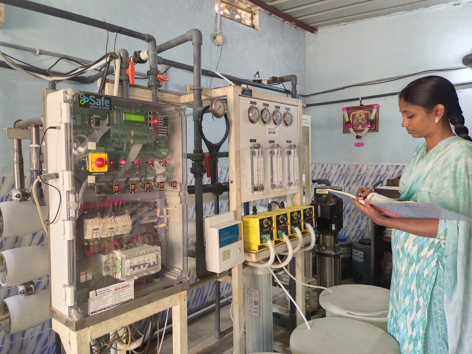
“The piped water still needs to be filtered and treated before it can be drunk,” says Poonam Sewak, SWN’s vice president for programs and partnerships, pointing out that an estimated 63 million Indians lack access to safe drinking water, and half of the country’s groundwater is contaminated with fluoride, nitrate and heavy metals. The network’s iJal stations with attached water ATMs offer high-tech and decentralized safe water access solutions in India and Ghana.
Building a corps of rural water entrepreneurs
The network’s water ATMs operate in several districts in Telangana, Maharashtra and Uttar Pradesh. Some are co-owned and run by self-help collectives of five to six women, while others are run by single entrepreneurs. The entrepreneurs provide the fixed assets and water source, usually a borewell on the premises. SWN contributes technical expertise to set up a reverse osmosis water filtration unit, provides marketing support and maintenance help and trains the entrepreneur to operate and maintain the water station and ATM. All in all, an iJal station costs under Rs 20 lakh (about $2,400 US) to set up and can service around 350 households. Sindhuja reckons she gets about 200 customers every day.
Creating clusters of iJal stations is crucial to this model, as this enables SWN’s technical staff to monitor and maintain the stations efficiently and cost-effectively. On average, each cluster with 30-plus stations creates about 60 to 100 jobs. This leads to what Kurt Soderlund, CEO, and Venkatesh Raghavendra, vice president, of the network described in an article in the Wharton School’s business journal as a “virtuous cycle, in which “[f]amilies participate, using more, safe water, leading to a healthier population and improved livelihoods.”
 The network’s water ATMs operate in several districts in Telangana, Maharashtra and Uttar Pradesh. Credit: Safe Water Network
This is one of the many ways in which water entrepreneurship has been facilitated in underserved regions across Africa and Asia. While this model trains new business owners as well as provides technical and maintenance assistance, other models are more hands-off. For example, the for-profit African company Jibu has a network of franchises, which purify existing water sources in high-density communities and distribute water to the neighborhood within walking distance of their storefronts.
Jibu’s one-time paid transfer of water filtration technology to rural entrepreneurs probably costs less in terms of time, energy and money, compared to the SWN model, which continues to maintain the ATMS and handhold its iJal station owners through their working lives. Consequently, the stations’ water revenue does not cover all the costs — of water advocacy; monitoring, evaluation and maintenance; water quality testing; and field supervision costs — which are mostly subsidized by the network’s donors.
Crushed by negative news?
Sign up for the Reasons to be Cheerful newsletter.
[contact-form-7]
This makes the SWN model highly dependent on philanthropic funding. In 2020, SWN’s biggest donor, Honeywell, decided to shift its funds to Covid relief and environmental sustainability. “We have other donors like PepsiCo, Oracle, Macquarie and Pentair Foundation, so there was no pause in our programs,” Sewak says. “But it was tough.”
However, this stream of funding is also why, as Sewak points out, Sindhuja’s and other ATMs have been working smoothly since 2017. “None of our stations have closed down,” she says. In some cases, she notes, stations have been “lifted and shifted” because the community wasn’t buying the water or because there were issues with the machine or the entrepreneur.
“Why should I spend on drinking water?”
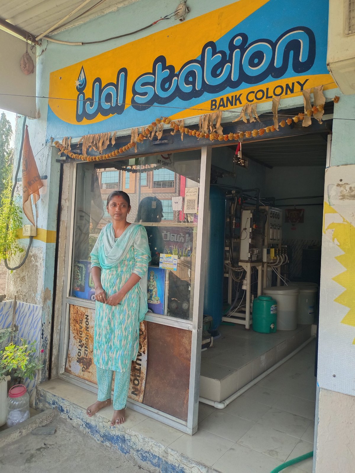 Sindhuja set up her iJal station seven years ago. Credit: Raj Kumar / Safe Water Network
Sindhuja says one of the initial challenges she faced was in convincing people that drinking clean water was imperative for their continued good health — even if it meant paying for it. Many other similar projects across the world have observed a similar hesitation to buy drinking water. “Some even said that the iJal water tasted different from the water from their wells and borewells,” she recalls.
To this end, SWN conducted large-scale outreach programs to educate people about the necessity of safe drinking water and improved the branding and signage at all their iJal stations. “We have also trained all our station operators to become safe water advocates,” says Sewak. Sindhuja uses her TDS meter (which measures the total dissolved solids in water) to show skeptical customers that the water from her ATM is cleaner than untreated water. Also, the palpable impact of drinking clean water has told its own story. An impact assessment report in 2020 found that the reported incidence of waterborne diseases among water ATM users in Telangana declined from 34 percent to 23 percent over a period of three years. Sixty-three percent of users reported a reduction in medical expenses and 73 percent, a reduction in school absenteeism.
Vanitha Baloth, 30, comes to Sindhuja’s water ATM every day to buy drinking water for her household. “My parents and I have been drinking this water ever since we moved to this neighborhood six months ago, and none of us have had diarrhea, dysentery or any other waterborne disease during this time,” she says. Baloth lives across the road, but in general, last-mile connectivity poses a challenge as customers still have to ferry heavy containers from the iJal stations to their homes. Sindhuja says she often helps elderly customers carry their water cans home.
Become a sustaining member today!
Join the Reasons to be Cheerful community by supporting our nonprofit publication and giving what you can.
Integrating water purification with doorstep delivery could help. For example, the Indian company Janajal (Hindi for “community water”) operates water ATMs in and around Delhi, as well as at several railway stations. In 2019, the company introduced clean fuel-powered three-wheeled vehicles that deliver clean water directly to communities, reaching both prime urban and deep, previously inaccessible rural areas. SWN “tried several water distribution models in India as well,” Sewak says, “but this increased the cost of the water.” It is worth noting that the network does operate a piped drinking water program in Ghana. In India, however, since the Indian government’s Jal Jeevan Mission already aims to provide tap water supply to every rural household by 2024, it is focusing on safe drinking water as the government water supply cannot be drunk without being filtered.
 “I earn about Rs 15,000 to 20,000 per month from this, which is amazing as there are hardly any jobs available to women like me here,” Sindhuja says. Credit: Raj Kumar / Safe Water Network
Another issue lies in the fact that the clusters of iJal stations are by and large dependent on groundwater extraction, which depletes a limited supply, and makes them vulnerable to any drops in groundwater levels brought about by climate change or overuse. “Today, as the government is moving towards water safety in its sustainable development goals, we have developed an automatic chlorination and online monitoring system, which digitally monitors and chlorinates water in the overhead water tanks installed by the government,” Sewak says. “This last-mile chlorination removes microbes that have contaminated the water as it is transmitted through pipelines, making it safe to drink.”
Meanwhile, Sindhuja is upbeat about the future of her “social business.” “Reverse osmosis filters are expensive to run at home. My water ATM offers a cheaper and equally good alternative,” she says. “Today, the iJal station supports me and my family, and together we support our entire neighborhood.”
The post The Cheap, Clever Promise of ‘Water ATMs’ appeared first on Reasons to be Cheerful.
Solar Pumps Are Empowering Women Farmers in India
Narrow roads lead to Harpur, flanked by small houses with expansive courtyards on both sides. Harpur is a small village perched at one corner of the Bandra block in Muzaffarpur district in the Indian state of Bihar, and though it may look like any other rural village, it is home to a group of women farmers who are at the forefront of a revolutionary change.
Historically, this region has grappled with water scarcity, which sharply limited the crops that farmers could cultivate. But since women-led self-help groups stepped in and installed solar pumps to provide affordable clean energy for irrigation, the scenario has changed dramatically. And along the way, these groups are challenging traditional gender norms, making women farmers a catalyst for climate adaptation.
The post Solar Pumps Are Empowering Women Farmers in India appeared first on Reasons to be Cheerful.
Conservative Idaho: Poised to Resist Sprawl?
by Dave Rollo
Idaho’s Sawtooth Mountain Range. (USDA)
The USA, Canada, and other countries have long recognized sprawl as a vexing dimension of urban development. Especially challenging is the difficulty creating the public consensus needed for political and planning responses to the problem.
But growing numbers of residents today are expressing their distaste for sprawling approaches to development and are primed to resist it. Perhaps surprisingly, sprawl afflicts a U.S. state better known for its natural beauty and its potatoes: Idaho. Even more surprising, and hopeful, is the growing opposition to sprawl among the state’s citizens.
An Urban Malignancy
Sprawl, one of the chief products of the urban growth machine, entails a development and building pattern that is damaging to the environment and to a community’s quality of life.

The monotony of sprawl replaces farmland and natural habitat. (Mark Strozier, Flickr)
Characterized by an expansive diffusion of roads, housing, and other built infrastructure, sprawl has become ubiquitous across the USA and Canada. With its emphasis on separation of commercial, residential, and public uses, sprawl employs great quantities of concrete and asphalt infrastructure and promotes car use. Furthermore, its high energy demands are maladaptive for a future of energy limits. Lax and aesthetically unimaginative design standards create a monotonous landscape that swaps traditional beauty for strip malls, big box stores, and McMansions.
Sprawl eats up natural habitats, demands huge amounts of resources and energy, and leads to isolation, social segregation, and other societal harms. However, in the short term, sprawl generates profits for development interests, especially when demand is high, and when planning codes permit or even encourage it.
Losing Natural Assets
Idaho is ecologically rich and abundant in quality farmland, rangeland, and water resources, assets threatened by pro-growth development in cities and counties across the state.
Idaho is often ranked in the top tier of states endowed with natural beauty. It borders Yellowstone National Park and the Grand Tetons and includes the strikingly beautiful Sawtooth Mountain Range, which runs through the center of the state. That range boasts four unique plant and animal communities and provides habitat for numerous species. Idaho’s natural features also include sagebrush steppe, an ecosystem that supports 350 rare, threatened, and endangered species.
Besides its magnificent wildlands, Idaho is endowed with a vibrant agricultural base, composed of some 25,000 ranches and farms. Food abundance is evidenced by the state’s seventh-place ranking in the USA for agricultural exports per capita. Furthermore, 26 percent of Idaho’s agricultural land is considered “nationally significant” by the American Farmland Trust; that is, it ranks among the best in the nation for long-term food production.
Yet Idaho’s natural assets are threatened by population pressure, which often drives land conversion. Idaho is one of the two fastest-growing states, with immigration from California accounting for nearly 40 percent of Idaho’s population increase in 2021. Spokane Public Radio reports that Idaho is projected to add 800,000 residents by 2060, an increase of 42 percent from the current population.
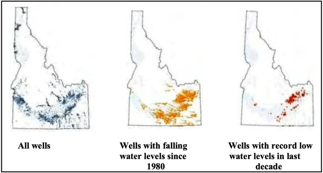
Aquifer depletion is already a problem in Idaho. (NumbersUSA)
This population pressure was largely responsible for the loss of some 370,000 acres of farmland and natural habitat between 1982 and 2017. The nationally significant share of agricultural land was more than three times as likely to be developed as other cropland. Population increase and attendant sprawl negatively impacts the sagebrush steppe in Idaho, with the greatest decline in ecological integrity in the fastest-growing regions of the state.
Apart from displacing cropland and wildlife habitats, new residences place added pressure on water tables, which are falling in Idaho. As aquifers trend toward depletion, allocating more water for a growing population will only serve to exacerbate the problem—in part through arguably wasteful uses of water, such as irrigation of turfgrass lawns, which competes with agricultural irrigation. Increased economic activity also generates contaminated stormwater, septic leakage, and yard pesticides that seep into groundwater and adversely affect aquifers.
Gauging Sentiment and Building Consensus
Prospective increases in the human population and the evident failure of land use regulations to limit the impact of growth have alarmed many residents of Idaho. Concerns about farmland loss and the degradation of Idaho’s environment prompted a 2023 study to assess the problem of population growth and sprawl in Idaho and take the pulse of the populace.
The overwhelming majority of Idaho residents see population growth as a problem. (www.IdahoSprawl.com).
NumbersUSA, a non-partisan, non-profit organization that advocates for “sensible immigration reform,” published a report on the study last month. The report establishes in detail the degree of habitat and farmland loss over several decades. Of the 370,000 acres lost, 77 percent was due to population increase, while 23 percent was caused by land conversion by the existing population.
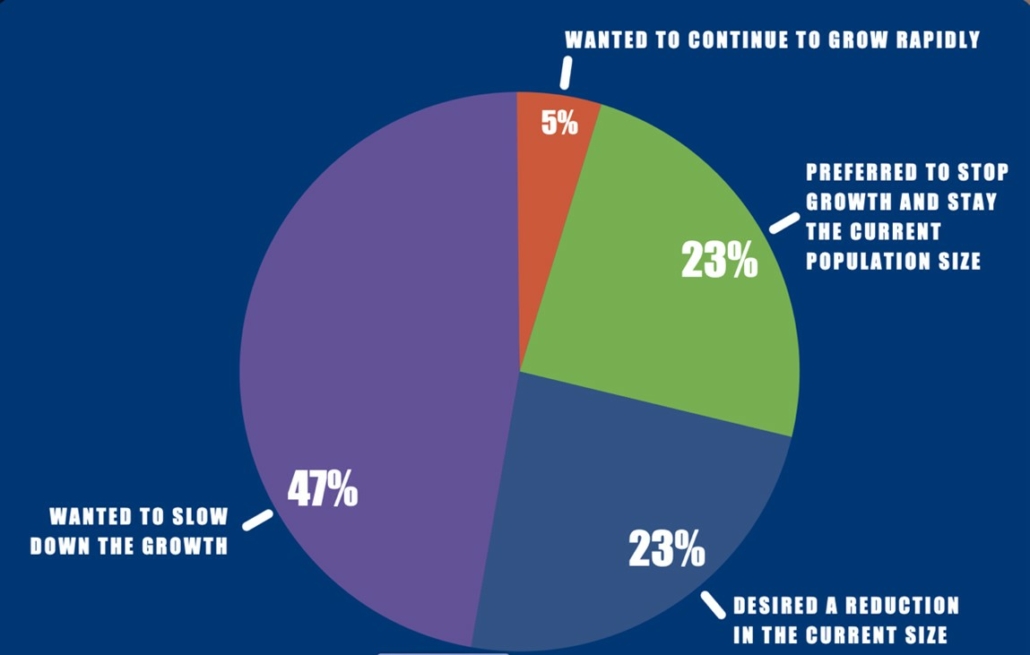
The report also contains a survey of Idaho residents conducted by Rasmussen Reports that documents public awareness of sprawl and concern over it. More than three-quarters of respondents believe Idaho’s growing population negatively affects its open spaces and environment. And fully 93 percent see current growth as a problem and wish to slow, reverse, or stop it.
Furthermore, aquifer depletion is on the public’s mind. Some 73 percent of respondents oppose diverting water from agriculture to development. Clearly the citizens of Idaho understand that it’s not in their interest to compromise a precious and limited resource.
Addressing the Problem
Besides assessing the contextual problem of sprawl in Idaho, the report addresses how urban areas could implement zoning code changes to restrict encroachment of development, thus protecting farmland and natural features such as forests or sagebrush steppe.
Permissive land use (zoning) codes are one way sprawl is unleashed. Sprawl is also promoted when developers are not required to internalize the costs of added community infrastructure, such as water and sewer lines. Their development activity is essentially subsidized by taxpayers.
Various zoning tools can mitigate the impact of sprawl by incentivizing density. Tools such as the transfer of development rights, infill strategies, and permitting multifamily apartments instead of single-family housing all help to limit diffused development patterns. Implemented appropriately, these tools can increase density in ways that increase overall livability.

Sentiments of Idahoans on zoning that encourages high-density development. (www.IdahoSprawl.com).
The NumbersUSA poll indicates that Idahoans are split on this approach, with 42 percent favoring regulations that encourage apartments and condos over single-family housing versus 47 percent strongly or somewhat opposed to such regulations.
While the approach of internalizing costs—that is, increasing development fees to offset the costs to the community for new development—was not directly addressed by the poll, Idahoans are resoundingly opposed to public subsidization of new development. Nearly 80 percent of respondents expressed opposition to paying higher property taxes to cover the infrastructure costs of new subdivisions.
Pressure on public infrastructure such as roads, sewers, water utilities, police and fire stations, and schools increases with an expanding population and its growing economy, and these facilities often become overextended. The costs of such services are supposed to be borne by the new residents, but are externalized to the existing residents.
One way to prevent such externalization is to impose caps on services. For example, sewer hook-ups can be limited. Limiting hook-ups to sewage lines and wastewater treatment plants was favored by half of respondents, while 22 percent were unsure and just over a quarter were opposed.
Up to the Challenge?
While it’s clear that population growth and the development pressures that follow are negatively affecting residents of Idaho, their county and municipal governments are having a limited impact in restraining sprawl as planners continue with a business-as-usual approach to development.
Recognizing sprawl as a threat should be made explicit within county planning documents and clear measures to limit sprawl should be specified. Yet, the comprehensive plans of seven of the eight fastest growing counties in Idaho mention ‘grow’, ‘growth,’ or ‘growing’ 1063 times in all, while sprawl garners only 15 mentions. And most of the references to growth focus on how to accommodate it; little mention is made of growth’s negative impacts.
Greater density can mean greater livability (La Citta Vita, Wikimedia Commons)
Boise is Idaho’s largest city and its capital. It was also one of the first communities in the state to experience the impacts of sprawl. Sprawl from Boise continues at a fierce pace with 24,000 new residents pouring into the city in just the past 2 years. “Blueprint Boise” is the 2021 updated comprehensive plan for Boise, whose more than half a million residents comprise over a quarter of the population of Idaho.
While Blueprint Boise is similarly light on references to sprawl (a single mention), it offers some measures to mitigate sprawl. In response to population pressures, the comprehensive plan adopted strategies to add density and to guide growth within a set of neighborhood and area master plans.
But critics of the plan complain that it does not adequately describe the consequences of growth and sprawl. And they blame continued loss of farmland and other open spaces on the failure of regional coordination, especially the absence of concurrency. Concurrency is a planning concept that mandates that adequate public facilities be in place before development is approved.
The threats to Idaho’s natural places, farmland, and rangeland will continue as population and economic pressures mount. Most of Idaho’s counties are ill-equipped to address the pressures that come with the surge in population. Recent efforts to make clear to Idaho’s elected officials that action is needed are also bound to intensify. Bold action is required soon. Which communities in Idaho will choose to lead on confronting the problem of sprawl, inspiring others to follow?
Dave Rollo is a Policy Specialist at CASSE.

The post Conservative Idaho: Poised to Resist Sprawl? appeared first on Center for the Advancement of the Steady State Economy.
Water Struggles as Resistance to Neoliberal Capitalism: a time of reproductive unrest
Water lubricates the global political economy; it is an essential service, infrastructure, a raw input to energy production and agriculture, increasingly an eco-system service and is necessary for life in all its forms. Water, its presence and lack, determines not only how and where, but also who, will survive. Which is simply to say, we cannot do without it. Yet 2 billion people continue to live without access to drinkable water and over 25 percent of the world’s population live in water stressed environments. These numbers are predicted to get worse as we face an intensifying global water crisis. But with increasing floods and extreme weather it is clear that the global water crisis is not just about a lack of water. So, what do we mean by a global water crisis? Why are we in crisis? What is the water crisis’ relationship to the ecological crisis? To the crisis of social reproduction? Or the crises of political legitimacy? And could it be a potential crisis for capitalism? These are all questions that animate my new book Water Struggles as Resistance to Neoliberal Capitalism: a time of reproductive unrest, in the Progress in Political Economy book series with Manchester University Press.
 The history of water governance tends to reflect dominant historical socio-political trends and the ways that different societies understood our relationship to nature. In the early twentieth century across much of the industrializing world the control of water went hand in hand with a nation-building ethos through projects such as dams or irrigation systems. At the same time, urban water services were expanded as a way to counter the rise of disease following rapid urbanization following industrialization. These same services were then key targets for experiments in privatisation in the early stages of neoliberalism – Chile under Pinochet developed some of the most market-orientated water policies, and England’s water services are one of the few fully privatised water services and infrastructures thanks to Thatcher (recent news stories of rising prices and constant poor water quality show what the consequences of these experiments have been). In recent years we have witnessed a murkier division between public and private investments and governing rationales through dynamics of financialization. The 2023 UN Water Conference – the first dedicated UN conference on water in over fifty years – concluded with calls to further mobilise the private sector to fill the financing gap that faces SDG6 (water and sanitation). The claim I develop throughout my book is that the way water is managed, who it is allocated to, where, why, how and when shows a lot about what a society values. Water policy and struggles over water act as a revealing window onto the values, contradictions and potential points of rupture that mark our conjuncture.
By expanding social reproduction theory onto questions of nature, I offer a labour-orientated approach to understanding crisis and the ways that communities have resisted the expansion of the water commodity frontier. The book employs an incorporated comparison of two water grabs at different points in the hydro-social cycle: 1) the enclosure of water services in Republic of Ireland and the anti-water charges protests that erupted in opposition; and 2) the enclosure of water resources by the gas industry and struggles against the gas industry in rural Australia. Exploring two cases in the global north was a political choice in order to highlight both the way that policy experiments in the Global South during the 1990s/2000s are returning to the capitalist core, and that water grabs do not only occur in states with weak institutions who are more vulnerable to transnational corporations but rather that states actively create the conditions for water expropriation to occur. Focussing on the period between the 2008-10 global financial crisis (GFC) and the start of the Covid-19 crisis, I show how each water grab reflects a different, if inter-related, facet of a system that continues to undermine the capacity for life- making. In both cases water as nature, or water as social reproduction, were reimagined as water as commodity to resolve existing accumulation crises.
In Australia, nature has historically been employed as the ‘tap and sink’ underpinning economic growth through either extractive industries or agriculture. Yet with the unconventional gas industry we saw a more explicit overlap of the agriculture, gas, and water commodity frontiers. Drilling changed both the quality and quantity of water available and for rural communities this is a waterscape that their livelihoods and social reproduction capacity relied upon. Agricultural communities who were once the forefront of colonial white frontier expansion and key to the legitimation of the Australian state, found themselves on the periphery of state projects increasingly orientated towards the interests of the global gas industry. However, even in face of ecological, economic and an increasing political crisis – the state responded with an intensification rather than transformation of existing extractive policies.
In Ireland public water services were targeted for restructuring following the financial and European debt crises and working class communities shouldered the consequences. The dominant accumulation strategy leading up to the GFC was on being an English-speaking gateway to Europe for US transnational and financial corporations. The Irish state chased investment through friendly tax and land policies. Yet the lack of a welfare state and overreliance on income tax for state revenues meant it was highly vulnerable to financial crises: When global finance was doing well, Ireland’s economic markers were strong, yet when there was a financial crisis these markers – which are largely fictitious profits – tumbled. In contrast to other bailout states that had strict conditions imposed upon them, the Irish government used the crisis to re-introduce policies such as water metering and charges that had been on the political agenda for decades. They were, as one interviewee described, ‘the EU’s poster boy for austerity’. Introducing water charges (up until then water services had been paid for out of general taxation) and restructuring Irish water services would allow the state to borrow from international financial markets in order to fund much needed repairs of long-term leaky infrastructures. However, for many protesters this also signalled the first step towards future privatisation of an essential service; water policy reflected the wider issues of an austerity state that had prioritised the interests of the financial sector over its citizens. The economic crisis (Ireland exited the bailout in 2013) was fixed through the manufacturing of a social crisis for working class communities, and the Irish water grab was a “fix” that would allow for the continuation of the existing accumulation regime.
In both cases, policy response to crisis saw an intensification of what came before rather than transformation. Yet by doing so, the vulnerable position of each state’s accumulation strategies within the global political economy were made explicit. Underlying crisis tendencies were not resolved, but rather shifted to the conditions that make accumulation possible, namely, social reproduction, nature, and, increasingly, the state. Taking up David Harvey’s conception of a spatial fix and reading it through social reproduction theory, I develop the notion of a spherical fix to show how crises are moved between these spheres as a form of crisis management. A spherical fix defines these conditions as extra-economic but still intra-capitalist – accumulation could not happen without them – as such crises in these spheres may have the potential to be crises for capitalism.
However, this is not just a story of policymaking but also of resistance, as through the spherical fix communities were newly politicised, the political terrain was reconfigured, and new subversive rationalities emerged as labour gained class agency. In Australia, farmers “locked their gate” to the gas industry by first putting yellow triangles on their fences, and then declaring whole communities ‘gasfield free’. The community to be defended was produced through struggle in resistance to an invasive industry. The Knitting Nanas Against Gas (KNAGs) would protest by knitting in front of drilling equipment or politicians offices and play on the imagery of “nannas” caring for ‘the future generations of kiddies’. Cementing an underlying feeling that existing political institutions were no longer representative, the movement focused on participatory rather than representative democracy. By understanding that water is a flow resource that requires cooperation and inter-generational management, rural communities re-articulated society and nature as inter-dependent, countering socio-nature as an alienated relation underpinning expropriation. An incoherence with the dominant logics of the state and market emerged, defining a class antagonism drawn on ecological lines. Many drilling licences in New South Wales were bought back by the state and Victoria now has a moratorium on unconventional gas drilling, however, the next gas commodity frontier is the Beetaloo Basin in the Northern Territory which would have disastrous impacts for First Nations people and would emit 117 million tonnes of CO2 annually.
In Ireland, the focus on water as social reproduction infrastructure quickly evolved into a broader critique of the state and related institutions, including representational democracy. As well as over 50% of the population refusing to pay their water bills, the water charges protests were some of the largest public protests since independence and were the largest anti-austerity protests in Europe per capita. They brought together working class communities who had not been active before, trade unions and left political parties. Water as social reproduction and related infrastructure was understood as a collective right that should have been disarticulated from processes of capital accumulation. In making these demands, the limited capacity of the state to account for this collective right came into sharper focus: the material conditions for a collective right to water – well-resourced public infrastructure and social safety nets – alongside systems of political accountability could never be realised within the dominant accumulation regime orientated towards the interests of global financial capital. This call has since spread to other protests including housing, healthcare and especially the Repeal the 8th movement for abortion rights that concretised the contradiction of an expansion of social rights without any changes to the material conditions that would allow for those rights to be realised.
In each social struggle a common relation to expropriation allowed solidarity across and within communities. And communities concretised a key contradiction of neoliberal capitalism: the increasing incompatibility of the conditions necessary for profit-making and life-making. To return to the initial question of the global water crisis and its implications, much more than water appears to be in crisis, and although there has been no rupture in neither Ireland nor Australia the structuring conditions of global capitalism appear brittle after this time of reproductive unrest.
The post Water Struggles as Resistance to Neoliberal Capitalism: a time of reproductive unrest appeared first on Progress in Political Economy (PPE).
‘Take It Down and They’ll Return’: The Stunning Revival of the Penobscot River
About a week before the removal of the Great Works Dam on the Penobscot River in Old Town, Maine, Dan Kusnierz dragged his sons to the riverside to take their picture in front of the aging structure. They had just come from a little league game. “They were being goofy and didn’t understand it,” Kusnierz, the water resources program manager for the Penobscot Indian Nation, recalls. It was 2012, and with the dam’s removal imminent, the river — New England’s second-largest — was about to transform.
For nearly two centuries, the Penobscot had been choked with logs and pulp as the timber and paper industries — both long-standing cornerstones of Maine’s economy — used it both as a lumber byway and waste receptacle. From just 1830 to 1880, more than eight billion feet of timber floated down the river. To power all this industry, dams were erected, 119 in the Penobscot River Basin alone. Two in particular, the Great Works and the Veazie, posed an outsized threat to the river’s health.
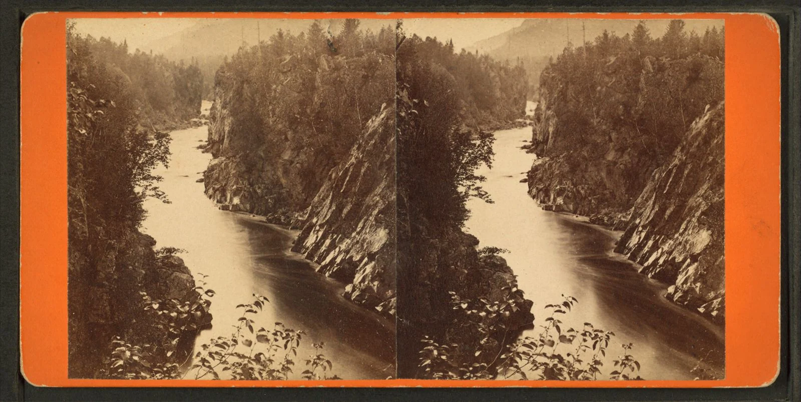 A stereograph from the 1870s shows the view from Ripogenus Falls on the Penobscot River. Credit: A.L. Hinds / Miriam and Ira D. Wallach Division of Art, Prints and Photographs, New York Public Library
Perhaps irrelevant to his children posing for a picture at the time, Kusnierz, who is not Penobscot but has served the Nation for 20 years, was one the members of an unprecedented coalition of scientists, Indigenous people and conservationists working to remove both dams in order to free the Penobscot River and hopefully restore its health in the process.
The river had been sick for generations. Butch Phillips, a Penobscot Nation elder, recalls growing up on Indian Island, the Penobscot tribe reservation located near Old Town on the river, in the 1950s. By that time, the Penobscot was unrecognizable to the body of water it had once been, with drifting logs so gridlocked at times on the eastern side of the island that the river was impassable for boats and people alike. This posed an ongoing dilemma for the Penobscot people who, prior to the construction of a bridge in 1950, used canoes to travel to and from the mainland.
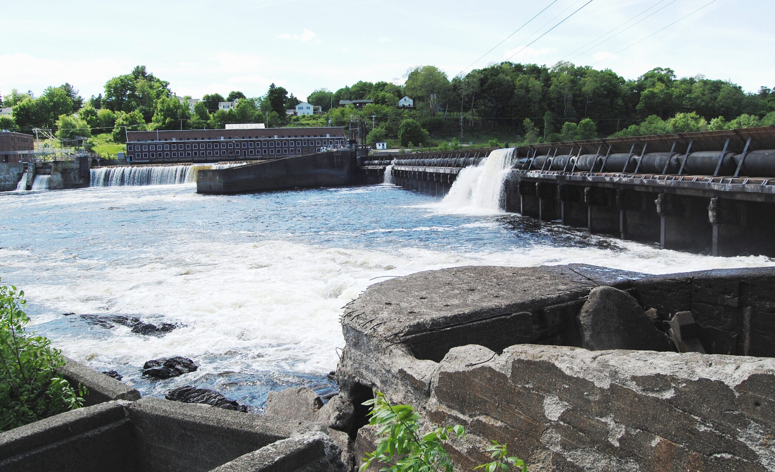 The Veazie Dam before removal. Credit: Joshua Royte / The Nature Conservancy
Despite the discharge coming from the mills, the river was still central to the Penobscot Nation’s everyday life. “[The river] was our playground,” Phillips says. “We were either canoeing on it, fishing, swimming in it and in the wintertime we were skating on it.” But the relationship had been affected. Living so closely with a body of water like the Penobscot for so many generations, he explains, “you develop a river culture. We are river people, we’re canoe people. And when you take away that element, that river and the use of the river, then you take away the culture as well.”
One of the worst blows to the river, though, was to its 12 species of sea-run fish. The Great Works, Veazie and Howland dams, all built in the 19th century, severed access to the river’s headwaters, which fish like alewives and shad, shortnose sturgeon and Atlantic salmon used as spawning ground. When the dams were erected, the effects on the fish population were almost immediate: By the 1850s, salmon no longer inhabited most of the rivers in southern Maine and their populations continued to decline so dramatically that in 1889, the US government opened the Craig Brook National Fish Hatchery in Orland, Maine to support the besieged fish. For the next 50 years, it was the primary source of salmon eggs for the region.
Credit: Kea Krause
The Craig Brook National Fish Hatchery has been raising Atlantic salmon, an iconic species of the northeastern US, since the late 19th century.
Yet salmon numbers continued to decline. By 1948, the final year of the commercial fishing industry for wild Atlantic salmon, only 40 were reported caught in the Penobscot watershed. In the late 1980s, around 2,000 salmon made it to the Veazie Dam (the first dam fish returning from the ocean encounter on the river), a number drastically whittled down from the species’ original population of about 200,000 annually. In 2009, wild Atlantic salmon were added to the endangered species list.
These were the stakes when the dams’ licenses were up for renewal in 1998, and leaders of the Penobscot Nation saw an opportunity to make a significant change to the status quo. The tribe’s plan was to purchase the dams — and then destroy them. So they joined with the Atlantic Salmon Federation to open a dialogue with the dam owner, a company called PPL Maine, to buy them. The cohort gathered more participants — American Rivers, the Natural Resources Council of Maine and Trout Unlimited — and formed an alliance called the Penobscot River Restoration Trust.
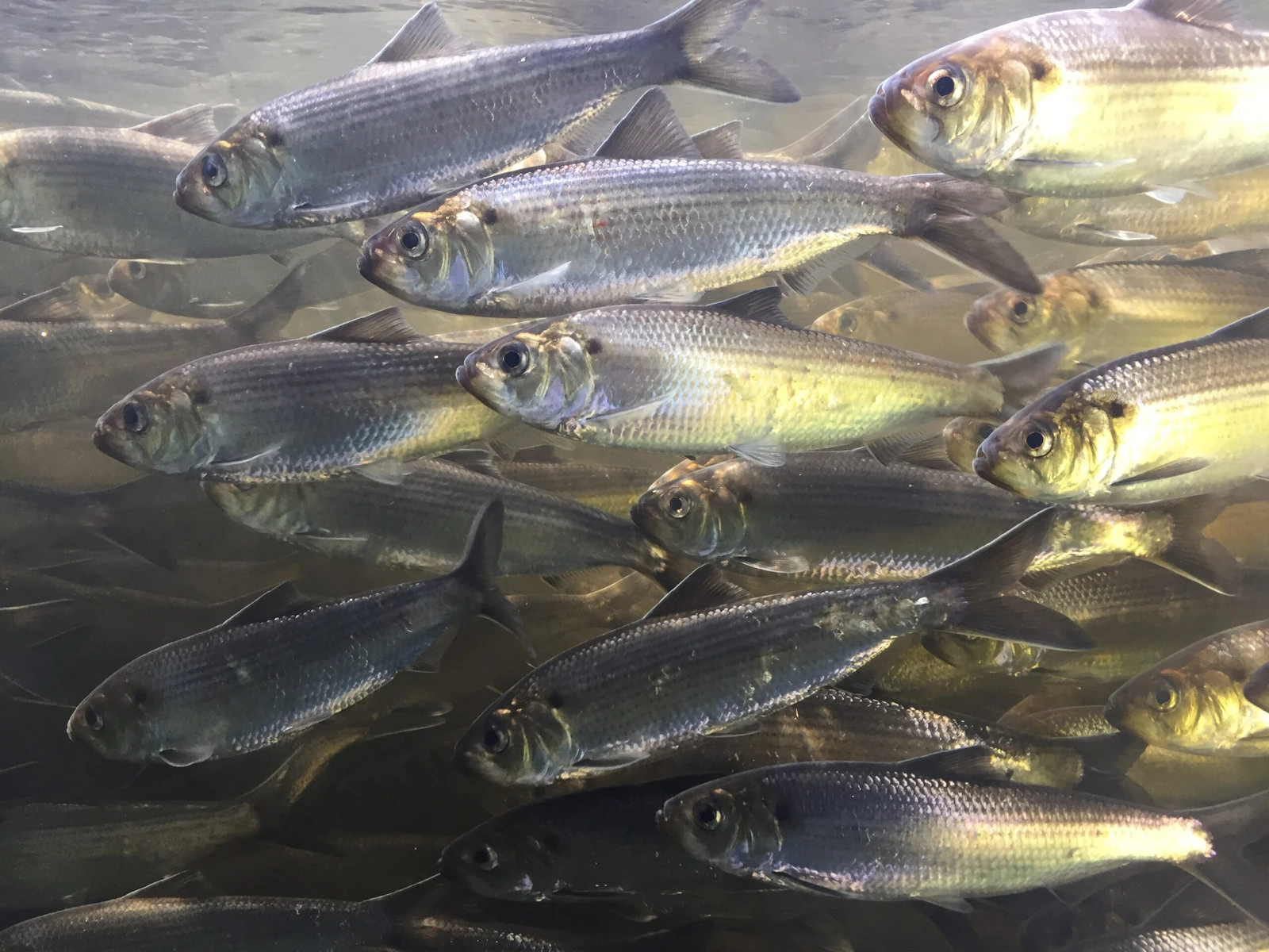 Alewives spend most of their lives at sea but rely on Maine’s inland waters for spawning habitat. Credit: Bridget Edmond / The Nature Conservancy
The river was in crisis: In addition to the dwindling salmon population, only two alewives were counted at the Veazie Dam in 2010 (NOAA estimates historically the river had 14 to 20 million), arguably one of its most alarming health indicators yet. Alewives, a type of river herring native to the Penobscot, feed just about everything and everyone, from the bottom of the food chain up. With no alewives, there would be no otter or fishers or osprey or eagles.
“The impacts of a dam are especially local,” says Laura Rose Day, executive director of the Penobscot River Restoration Trust. So while the Trust engaged in years-long negotiations with PPL, community outreach became an equally key component to the project’s success. Rose Day, along with Cheryl Daigle, an outreach coordinator for the project, and Butch Phillips, who was tapped as an ambassador for the Penobscot people, set out on a lengthy effort to share the good news of the project with the community. Individually, they logged hours of knocking on doors, maintaining tables and booths at sports shows, hosting the Penobscot River Revival Festival and just persistently showing up for people who came to them with questions and concerns.
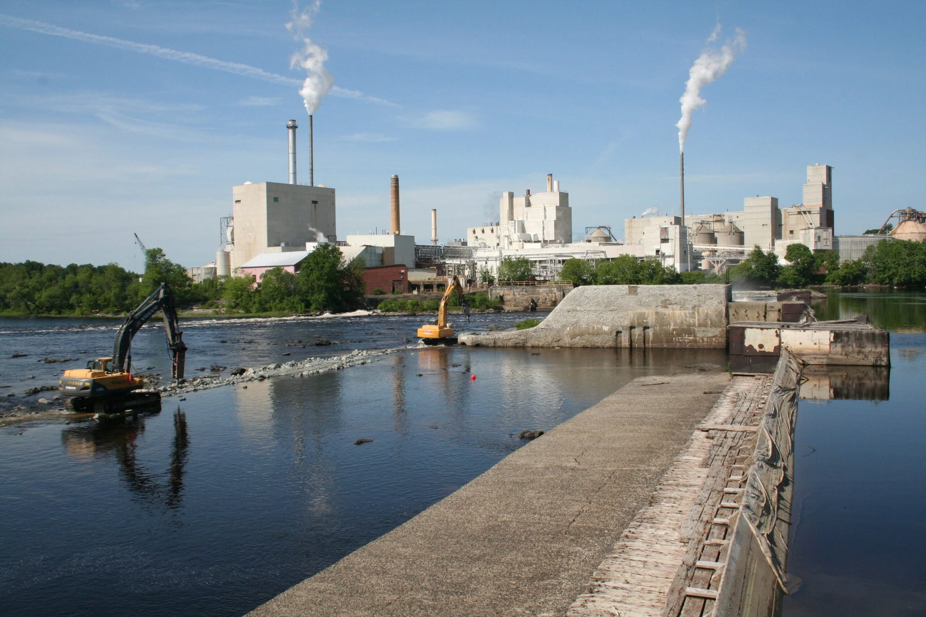 The Great Works Dam mid-removal. Courtesy of the Natural Resources Council of Maine
It wasn’t always easy to find receptive minds. “In the broadest sense, change is an obstacle,” Molly Payne Wynne, the project’s monitoring coordinator and project associate, explains. “You’re essentially coming into a community, and you’re asking that the one thing that they see every day, or the one constant that they know — this structure in the river — you want to remove that and totally change the visual and what that means for them.”
“The key to all of these projects is finding the right equation to meet public and business and Indigenous and other rights and interests and needs, based on the place,” Rose Day reflects. Daigle says she often found herself translating the science of the project for people and also managing the varying perspectives of how a river should be: “Part of it is not being afraid to venture into that territory where there’s conflicting views about use of a resource.”
Credit: Stephen G. Page / Shutterstock
“We are river people, we’re canoe people. And when you take away that element, then you take away the culture as well.” –Butch Phillips
For his part, Phillips discovered that there was a dearth of knowledge community-wide when it came to the tribe’s relationship to the river. “My ancestors have been on this river for literally thousands of years,” he notes. “And that connection goes really deep because through those many, many generations, the people depended on the river and the surrounding land for their everyday living: Their food, their shelter, their weapons, their transportation, clothing, everything came from the river and the land.”
Phillips felt it was crucial to add that perspective to the project. “I was talking about the connection of Penobscot to the river and the fish and all the creatures, and to many of those listening, it was the first time they heard it,” he says.
Crushed by negative news?
Sign up for the Reasons to be Cheerful newsletter.
[contact-form-7]
Daigle’s experience reflected a similar revelation: that communicating the science was important but, perhaps, what mattered more were small moments of communion that involved the river itself. After the dams were purchased, as some of their impoundments were being let out, there was an effort to move the river’s freshwater mussels to safety. For several weeks, Daigle, along with close to seventy volunteers, waded through the waters of Penobscot, moving the mollusks out of harm’s way. “It was sort of this intimate act to move these mussels, and build a little sense of community around that,” Daigle recalls.
The project was unprecedented in its ambition and its success. The Trust ultimately raised $60 million to purchase the Veazie, Great Works and Howland dams in 2008. In 2012, the Great Works Dam was the first to go, followed by the Veazie in 2013. The Trust was unable to convince the community of Howland to remove its dam, and so a compromise was reached in which a fish bypass was added to the dam to allow an open route for returning fish. As a result, nearly 2,000 miles of habitat was opened for salmon and other species.
 The Howland Dam bypass enables fish to pass safely through. Credit: Brandon Kulik / Kleinschmidt
In the nine years it took to come to an agreement with PPL, which included generating more power at alternate dams so there wouldn’t be a decrease in hydroelectricity, scientists were able to seize the opportunity to really study the river, and what happens to one before and after a dam removal.
Become a sustaining member today!
Join the Reasons to be Cheerful community by supporting our nonprofit publication and giving what you can.
When you dam a river, it’s like flooding a house. Water pools and settles, as does sediment, and what you get is a warm, still environment, nothing like the lively, textured existence of a flowing river. But when you remove a dam, the river’s rebound is robust and swift. In 2018, just six years after the removal of the first dam, more than two million river herring (which includes alewives) were counted passing through a local fish lift in addition to 772 salmon. “When we do on-the-ground restoration actions with these fish, they respond immediately,” says Payne Wynne. “It’s fascinating. And it’s unique in the restoration world, because in other spheres of restoration, it can take decades to see any real response to the actual, immediate restoration activity.”
The breaching of the Veazie Dam in 2013. Courtesy of the Natural Resources Council of Maine
Though the agreement and planning took several years, when the Great Works and Veazie dams were finally demolished, the river’s recovery was dramatic and swift.
The degree of the project’s success — the river’s surprising return — has bolstered hope that future efforts like it will only continue to improve the outlook for Atlantic salmon and other fish species. Though the Trust has since dissolved, work continues to remove dams further upstream along the Penobscot’s many tributaries, which would open up more cold-water spawning habitat to all the sea-run fish. But as the nearly 15-year effort of the Trust demonstrates, dam removals are arduous, persisting battles. A win is not to be taken for granted.
In contrast to the river herring, the salmon population’s recovery has been more modest, with around 1,500 returning to the Penobscot this year — the most since 2011 but still just a slight 10-year increase. “It’s a really hostile environment for Atlantic salmon in the North Atlantic right now,” says Rory Saunders, NOAA Fisheries’ Downeast coastal salmon recovery coordinator, referring to the challenges posed by climate change. “The Penobscot run in particular is almost entirely dependent on the hatchery at this point.”
 A pregnant salmon at the hatchery is held up for inspection. Credit: Kea Krause
At the hatchery this fall, 250 mature females prepared to spawn, their dappled bodies taut with eggs. The fish had migrated to the likes of Newfoundland and back, and now they swam lazily in their tank, a sign of late pregnancy. I stood in the tank observing the Fish and Wildlife techs as they scooped each female gently up in a net — taking hold of her tail and lifting her delicately, always supporting her head — for the inspection of a biologist.
The fish weren’t quite ready to spawn, but they were getting there, and learning this distinction took years of experience, of plucking expectant females from tanks and pinching their bellies, of discerning the difference between the feeling of a ziplock baggy full with water and one that’s bursting. These fish would need another week. Then the techs would do it all again—scoop, pluck, pinch.
Once the females spawned, the eggs would be fertilized and incubated, and eventually some would be placed in man-made salmon redds, tiny depressions made in the sand normally by the wiggle and swoop a female’s body, through a hole drilled in ice. This is the ritual—tender and technical—of saving the last wild Atlantic salmon on the planet.
“The Penobscot project is a tremendous first step, but it’s not a silver bullet. We need to continue to think about upstream habitat,” acknowledges Saunders. There are hopes to remove more dams along the Piscataquis River, a tributary to the Penobscot, which would allow for access to more good, cold water for the salmon, but this could take years.
Still, there is much to celebrate. “We went from 2,000 animals to five million animals in the span of 12 years. That’s as good-news-story as you see in ecology, as you see in natural resources,” says Saunders. The return of the salmon holds significance to the Penobscot Nation as well. “It’s not just the fish,” explains Kusnierz. “It’s restoring a huge part of the culture of the tribe. Those are their relatives that have long been gone and are here again. That’s what the vision of the tribe was in those negotiations. [It] was kind of the opposite of ‘build it, and they will come.’ It was ‘take it down and they’ll return.’”
 Butch Phillips and Barry Dana of the Penobscot Nation offer a blessing at an event celebrating the Great Works Dam’s removal. Credit: US Fish and Wildlife Service
In the tradition of the Penobscot Nation, Phillips has collaborated on the construction of two different birch bark canoes and in one instance, took the boat up the Penobscot toward Mount Katahdin, toward the headwaters. Phillips, along with other community members including one of his sons, was retracing the path of generations before him — up the river and toward the mountain, which never seemed to disappear from view despite the constant bend and curve in the water’s trajectory.
At one point, after a particularly tough paddle through an ancient waterway on the west side of the river, Phillips turned to his son. “I told him, Let’s stop, and we laid on the ground,” he recalls. The moment was one of providence: “We’re walking in the same footsteps as our ancestors have for thousands of years.” This was in 2002, prior to the removal of the dams, and the group had to maneuver the canoe around them on their journey. The restoration project was in its nascent stages then, and the hope to someday see the river healthy and unrestricted still seemed like a moon shot, even to Phillips.
“I’m just so happy that I lived long enough to see at least a portion of our river free-flowing, so that the sea-run fish can ascend the river and go to their ancestral spawning ground as they did before the dams went up,” says Phillips. “As my ancestors witnessed.”
The post ‘Take It Down and They’ll Return’: The Stunning Revival of the Penobscot River appeared first on Reasons to be Cheerful.
A Community-Driven Path to Replenishing Groundwater in a Parched Region
A lone tractor trundles along a bumpy road in Banda, one of the most drought-prone districts in the North Indian state of Uttar Pradesh. Up until a few years ago, soil here would dry and crack into fissures deep enough for unwary cows to fall in. Today, as we drive toward a little village called Jakhni, we see rice paddies usually found only in much wetter climes. A large pond comes into view, and behind it, Jakhni.
Thanks to a revival of old farming practices and growing community involvement in all matters relating to water, this village is now known in India as a model jalgram, or water village.
Jakhni is a settlement of barely 1,600 people, mostly farmers. Its stony, hilly terrain is typical of Bundelkhand, an arid region spread across parts of the neighboring states of Madhya Pradesh and Uttar Pradesh. This region receives between 800 and 1,300 millimeters of rainfall annually, but locals quip that like their children, who all tend to migrate for better opportunities, the rainwater runs off too. The rocks that lie beneath the region are not very porous, and there are relatively few aquifers (layers of underground water). As a result, most of the rainwater flows away from the region instead of being locally absorbed.
“Growing up, the water scarcity we experienced in Jakhni was scary,” Uma Shankar Pandey, a 52-year-old resident of Jakhni, recounts.
The post A Community-Driven Path to Replenishing Groundwater in a Parched Region appeared first on Reasons to be Cheerful.
Learning from Las Vegas: The Costs of Growth
by Daniel Wortel-London

The city of Las Vegas is gambling with growth—but the game is rigged. (LasVegasGuy, Creative Commons 4.0)
Since 1998, the City of Las Vegas and the U.S. Bureau of Land Management (BLM) have been gambling with nature. By auctioning off public land from the BLM for development and using the proceeds to preserve natural areas, policymakers and federal officials have bet that development and conservation can go hand-in-hand.
But it hasn’t worked out that way.
As the Las Vegas region has grown from 1.3 to 2.7 million people since 1998, it has suffered from the effects of sprawl, drought, and air pollution. And the ecological consequences of the city’s growth have largely canceled out the “conservation” provisions of federal-regional land use agreements.
The result is a local case that brings to life a much larger lesson: Maintaining the earth’s biocapacity and accelerating growth are mutually exclusive goals. By learning from Las Vegas, we can assemble the evidence and identify the coalitions needed to contest planet-wrecking growth policies across the country.
Selling Public Land
The BLM, which manages about one-tenth of the land area of the USA, is one of the most important federal agencies involved in public land sales. The Federal Land Policy Management Act of 1978, or FLPMA, sets many of the requirements and procedures for such sales.
It specifies that the BLM can select lands for sale if, as determined through a land-use planning process, they meet one of three criteria: 1) lands are scattered, isolated tracts that are difficult or uneconomic to manage; 2) they were acquired for a specific purpose and are no longer needed for that purpose; or 3) disposal of the land would serve important public objectives such as community expansion and economic development.

Satellite view of Las Vegas. The city’s sprawl is abetted by federal aid. (Goddard Space Flight Center)
In the last criterion, the meanings of “public objective,” “community expansion,” and “economic development” are critically important. But they are not defined clearly in the Act itself nor in the BLM’s Land Exchange Handbook. The best clue regarding BLM’s understanding of the terms is found in how it has managed actual cases of development. Las Vegas provides an excellent example.
The 1998 Southern Nevada Public Land Management Act (SNPLMA) provides the federal legislative template for aligning the interests of developers and conservationists in the region. The purpose of the bill was to “provide for the orderly disposal of certain federal lands in Clark County, Nevada, and to provide for the acquisition of environmentally sensitive lands in the State of Nevada.” It aims to accomplish this by drawing a boundary around the Las Vegas Valley and identifying public lands to be sold at auction to private bidders, while allowing the proceeds of those sales to be used to purchase “environmentally sensitive” land elsewhere.
In some ways the bill seems to have worked as planned. Some 34,468 acres of public land have been sold or exchanged for development purposes. This has provided $2.6 million dollars for environmentally sensitive land acquisitions, $17 million for miscellaneous conservation activities, and $54 million for park development. That’s a win-win, right?
The Costs of Growth
Wrong. First, not all money raised through land sales has been spent for environmental purposes. Funds have been used to build everything from shuffleboard courts to softball complexes, $60 million gun clubs, and a $5 million neon-sign museum. They’ve also paid for the parking lots, roads, and power lines leading to these amenities, all of which means more resource throughput.
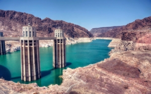
Las Vegas’s growth is putting pressure on the Colorado River, as evidenced by the bathtub rings near Hoover Dam. (Peter Theony, Creative Commons 2.0)
The biggest issue isn’t the use of money from land sales, it’s the use of the land purchased from the sales—specifically, the spawning of sprawling housing and commercial developments. Technically, local governments could request land sales only by demonstrating that the land’s use would follow comprehensive and “smart” plans. But planners in Las Vegas have, for the most part, been content to approve the kinds of automobile-centric plans that characterize much of America’s development around cities.
As a result, Las Vegas now suffers the ecological, fiscal, and social costs of sprawl. Worsened air quality, less open space, longer commutes, and poorer health all afflict the metropolis. The upkeep of Nevada’s roads alone now costs the state $10 billion annually, spurred partly by Las Vegas’s growth. Pollution-induced asthma rates among African-American youth in the city are now 30%. A lack of public transit prevents many citizens from accessing badly needed jobs and housing.
Overshadowing these ills is an even bigger malady: climate change. The Las Vegas Valley receives fewer than 5 inches of rainfall per year on average and relies largely on water drawn from the Colorado River to meet residential, industrial, and commercial demand. But the river is stressed by record droughts—droughts that will be exacerbated by the climate change accelerated by Las Vegas’s cars as the city sprawls ever-outward. Already, Las Vegas is one of the fastest-warming cites in the country, having experienced 5.7°F of average temperate rise over the past 70 years.
Round 2
Yet the drive to further plunder public land for the sake of growth continues. In 2021 a Democratic senator introduced legislation modeled on the SNPLMA that would effectively double the amount of real estate the BLM could sell to Nevada developers. A metropolitan area the size of Miami—42,427 acres, or approximately 65 square miles—will become available for sprawl in the Las Vegas region.
Nonetheless, many conservationists have supported the bill thanks to its provisions for habitat preservation—again, modeled on the SNPLMA. For example, the bill would conserve about 2 million acres of public land, add more than 1.6 million acres of wilderness, add 350,000 acres to Southern Nevada’s conservation portfolio, and permanently save the Red Rock National Conservation Area from development.

Fabulous Las Vegas—but for how much longer? (BrendelSignature, Creative Commons 3.0)
Thus, groups like the Las Vegas Metro Chamber of Commerce, the Nevada Conservation League, the Conservation Fund, and the Southern Nevada Homebuilders Association have aligned to support the self-contradictory “Southern Nevada Economic Development and Conservation Act.”
But not everyone is on board with the bill, and many opponents are sounding off to the media. The Nevada Climate Justice Coalition, comprised of social and ecological advocacy organizations, has united to fight it. They argue that the bill’s conservation measures are outweighed by its ecological costs. “While we support protecting public lands, designating a bunch of wilderness areas does nothing to ameliorate the climate or justice impacts of sprawl. It’s a false equivalence,” says Patrick Donnelly of the Center for Biological Diversity in an interview with the Nevada Current. “It disregards our future water supply. It disregards emissions, vehicle miles traveled,” Kyle Roerink of the Great Basin Water Network told the paper in a separate interview.
Meanwhile, Janine Blaeloch, Project Director of the Western Lands Project, told National Public Radio, “It’s salt in the wound for American taxpayers. Because we’re losing public land that’s being sold off, we’re losing money that’s being funneled into supporting sprawl in Las Vegas, but we also are unwittingly supporting really unsustainable development in the middle of the desert.”
The political appeal of these critiques, however, appears to be limited. Few local politicians and fewer national ones have taken up the cause of curbing growth in Las Vegas. As law professor Bret Birdsong notes, “Growth is a hungry mouth to feed, and growth itself is an industry…I can understand how that takes almost immutable political forces to solve that problem. And here, the problem is solved by privatizing more public lands.” Thus, for most politicians in Nevada the solution to the problem of growth is—more growth.
This strange logic has bipartisan appeal. As Representative Mark Amodei, a Republican, states, “We’ll have our fights over conservation, development, water, that sort of thing. But at the end of the day, you don’t have to have a degree in finance to [know] what will happen if those tax bases go static… In all modern times, growth has been the cash flow for local government and the state.”
Underlying the political hesitation to critique growth is the element of partisan competition. Las Vegas has turned blue in recent years; a critique of growth by Democrats might jeopardize their newly attained power. Brian Petersen, an environmental scholar at Northern Arizona University, sums up the political reality: “If you start saying, all of a sudden, ‘We’re no longer giving out building permits, we’re no longer allowing multinational companies to build a facility here, we’re shutting down golf courses’—you would have people in the streets rioting.” The result is that, in the words of journalist Kyle Paoletta, “Even as Democrats lead the national charge toward tackling climate change, they are continuing to preach at the altar of growth.”
The Road Ahead
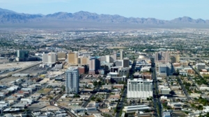
If Las Vegas is to have a future, it will need to stop growing. (Http2007, Creative Commons 2.0)
So, what is to be done? On one hand, the public can exert pressure to contest individual BLM land sales through public comment posts, letters to legislators, and letters to the editor. But the higher-level goal is to prevent public land sales from increasing environmental pressures to begin with. This can be done partly through more rigorous cost-benefit analysis of land sales to capture, for example, how much the ecological costs of sprawl would cancel out the conservation benefits of land preservation. But amendments to the Nevada bills must embed in them the true meaning of economic development and set true development as the bills’ chief goal and guiding principle.
None of this can happen, however, without assembling a strong political coalition. The Nevada Climate Justice Coalition, with its combination of social and ecological critiques of sprawl, provides a powerful model. Now is the time to support and expand their struggle by pointing out how other public policies on behalf of growth are also threatening people and the planet. But critique is not enough: We have to show how a degrowth-to-steady-state trajectory can not only avoid disaster, but actually improve outcomes for people.
Doing this will require research, persistence, and the courage to resist the blandishments of so-called “green” growth. I’m betting we’re up to the challenge.
Daniel Wortel-London is a Policy Specialist at CASSE.

The post Learning from Las Vegas: The Costs of Growth appeared first on Center for the Advancement of the Steady State Economy.